2011.05.27~2011.05.31 科羅拉多/新墨西哥 三天四夜國家公園行程
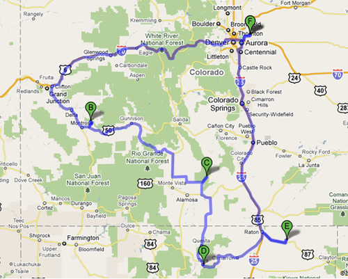
A和F:Denver airport
B:Black Canyon of the Gunnison NP,甘尼生黑峽谷國家公園
=> 可能可以考慮先去Colorado NM (科羅拉多保護區)看個日出。
C:Great Sand Dunes NP,大沙丘國家公園
D:Taos,陶斯(世界遺產)
E:Capulin Volcano NM,卡普林火山國家保護區
(備案:Royal Gorge Bridge)
總路程:~1200 miles
開車時數:~20 hours
5/27 8:07pm SNA=>DEN 11:17pm (夜車5小時可抵科羅拉多保護區,日出時間約5:30)
5/28 Black Canyon of the Gunnison NP,甘尼生黑峽谷
=> 4小時至Alamosa,住Super 8 ($80.88+tax)
5/29 Geat Sand Dones NP,大沙丘國家公園 (拍早晨沙丘景色,待到中午)
=> 2小時至Taos,陶斯
=> 2小時至Raton,住Microtel Inn ($71.71)
5/30 Capulin Volcano NM,卡普林火山
=> 回DEN,車程4.5小時
*中間若有時間可以去Royal Gorge Bridge
*住DEN機場附近的Microtel Inn ($76.31)
5/31 飛機8:08am~9:30am
預算估計:(6人)
機票: $197.4
住宿三晚: $239/6 ~ $40
Taos門票: $10 + $5(camera fee) = $15
租車(保險)+油錢: ($161 +$33 + $150)/6 ~ $58
——————————————————
~ $310/人
Trail Recommendation:
甘尼生黑峽谷國家公園 (the Black Canyon of Gunnison NP)
Rim Rock Nature Trail Moderate – 1 mile round trip.
As its name implies, this self-guided nature trail takes you along a relatively flat path following the rim of the canyon. Along this sunny route you will encounter a variety of plant life from sagebrush and Gambel oak to pinyon pine and Utah juniper. This trail allows many excellent views of the Gunnison River as well as the sheer walls of the canyon.
Painted Wall cliff Cedar Point Nature Trail Easy – 2/3 mile round trip.
An excellent place for one to brush up on the local flora, this short, sunny, moderately sloped trail offers guideposts describing the various plants along the way. At the end are two overlooks offering breathtaking views of the river over 2,000 feet below. Also visible is the famous Painted Wall, the tallest cliff in Colorado (2,250 ft), as well as rock islands jutting up from the depths of the canyon.
Warner Point Nature Trail Moderate – 1.5 miles round trip.
You can pick up a trail guide at the High Point Overlook or the South Rim Visitor Center. Along this trail you will find shady benches which allow you to rest among mountain mahogany, serviceberry, pinyon pine, and juniper. Looking south you can see the San Juan Mountain Range, Uncompahgre Valley, and Bostwick Park. To the north look for the West Elk Mountains, and at the end of the trail enjoy the views of the Gunnison River and the Black Canyon.
大沙丘國家公園 (Great Sand Dunes National Park)
Medano Creek
When there’s water in Medano Creek at the base of the dunes, adults and kids alike love to splash in the stream. Watch for waves in the water, a phenomenon called "surge flow." As mounds of sand form and fall in the creek bed, water surges, similar to the action of waves at a beach.
The Tallest Dunes
The "High Dune" is neither the highest in elevation nor the tallest in the park, but it looks that way from the main parking lot. It is about 650 feet (198 m) high. Cross the flats and zigzag up the ridgelines to reach it. The 360 degree view is inspirational. From High Dune, the skyrising dune you see to the west is the spectacular Star Dune, rising 750 feet (229 m). It is the tallest dune in North America. To reach it from High Dune, journey another mile and a half up and down across the dunes to its summit.
卡普林火山國家保護區 (Capulin Volcano National Monument)
Crater Rim Trail
is a paved, 1 mile loop around the top of the volcano. It is moderately difficult due to steep climbs and descents. Wayside exhibits with panoramic photographs provide visitors information about the surrounding features in the Raton-Clayton Volcanic Field.
Crater Vent Trail
is a 0.2 mile (one-way) trail leading to the bottom of the Capulin's Crater. This trail is paved and has an elevation change of 100 feet.
Lava Flow Trail
at the base of the volcano is an unimproved, 1 mile loop that crosses one of the volcano's lava flows. Pick up a trail guide at the visitor center to learn more about Capulin's lava flows and features along the way.